Ok, I’ll admit it, this may not be a hugely exciting topic, but scale factors are one of the most commonly misunderstood and under-acknowledged aspects of what we do. Yet they form a crucial aspect of successful surveying. As an Architect, Engineer, PM or QS, it’s essential to understand the importance of accurate and precise measurements in the measured survey process. One aspect that plays a crucial role in achieving this accuracy is the scale factor. In this article, we’ll explore the implications of scale factor in land surveys using the Ordnance Survey Great Britain (OSGB36) coordinate system.
Why do we have a Scale Factor?
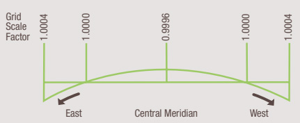
News Flash! The earth is round! Probably not the most surprising news you will read today but when dealing with map projections it is important. When projecting a curved surface onto a flat plane the scale factor helps to deal with the distortions. Why does this matter? Well when working with national grid projections, 1 metre on the ground does not always equal 1 metre in the drawing. In surveying, it’s crucial to consider the scale factor as it affects the measurements taken and can result in errors if not evaluated correctly

OSGB36 Coordinate System and Scale Factor
The OSGB36 coordinate system is a national grid system used in Great Britain for mapping and surveying purposes. In this system, the scale factor is different at each point on the grid and varies across the country. In essence, the scale factor at Newquay will be different to the scale factor at Peterhead. As you’ll see in the images below, the OS Grid varies when compared with latitude and longitudinal lines.
Implications of Scale Factor in Land Surveys
The main implication of the scale factor in land surveys is the impact it has on the measurements taken. If the scale factor is not taken into account correctly, it can result in errors in the measurements and, ultimately, the final survey results. Whilst the measurements may be accurate in both grid and ground, if the end-user mistakes one for the other then their understanding of what is happening on the ground will be incorrect.
For example, if a surveyor measures a distance of 1000 metres on the ground using a total station the same distance between the same two points may appear differently on the drawing if that drawing has been produced in OSGB36 using GNSS equipment. At my current location, this will have a difference of about 400mm over the 1km length. Whilst this might not make much of a difference if your site is 50m wide, it’s clear how this sort of error could cause significant issues if you’re building new roads or bridges!
How to Account for Scale Factor in Surveys
To ensure accuracy in the surveying process, it’s crucial to consider the scale factor and make necessary adjustments. This can be done using specialised software that considers the scale factor and corrects the measurements automatically. The most critical thing to remember is to always discuss your requirements in full with your land surveyor. There are different use cases for both ground and grid surveys and understanding the merits of each will be crucial to your success.
In conclusion, the scale factor plays a crucial role in land surveys, and it’s essential to understand its implications to achieve accurate and precise survey results. By taking the scale factor into account and making the necessary adjustments, surveyors can ensure the accuracy and suitability of their measurements and provide their clients with reliable and trustworthy survey results.
About Adaptive Surveys
Adaptive Surveys utilise the latest in survey techniques to produce highly accurate topographic and measured building surveys UK-wide. Focusing on the built environment, we produce high-resolution point cloud surveys across multiple industries.
We provide our clients with holistic, data-rich datasets comprising billions of measurable points. Regulated by the Royal Institution of Chartered Surveyors, we are a firm of survey professionals with decades of experience in the built environment. Our services include Laser Scanning, Mobile Mapping, Drone and Topographic Surveys, and 3D Modelling.
If you’d like to learn more, contact us today.


