Client
Design & Construction - Golf Course
Delivery
May - 2022
Project Type
Drone Survey
Location
Stonehaven, Scotland
Scope
Our client required a topographic survey of a large area of land for the design and construction of a golf course on the site. The site was approximately 270 hectares and consisted of areas of heavy vegetation, steep terrain, large elevation changes and arable fields in crop. A topographic plan to Ordnance Survey to an accuracy of +/- 50mm was requested along with an orthomosaic image of the site to provide additional context and visual reference to the topographic survey.

Solution
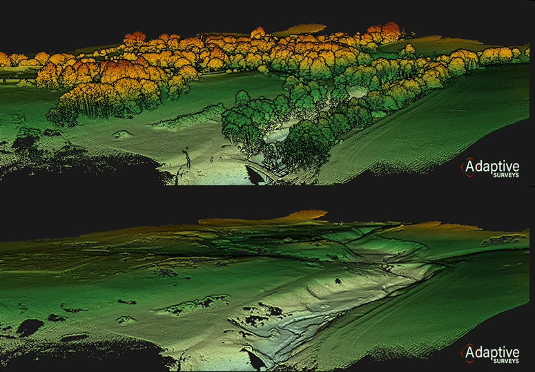
Aerial Lidar is perfected suited to such sites and offers a safe and efficient method of capturing accurate digital terrain models over vast areas. All our surveyors are CAA approved UAV Pilots with hundreds of flying hours logged on a variety of unmanned aerial systems. Though detailed planning and execution the site was covered over 15 individual UAV missions, collecting 95Gb of raw data.
To ensure stated accuracies were achieved ground control was established at suitable locations across the site using NRTK GNSS methods. The use of GCP’s provides for accurate and identifiable points within the data which can be used for constraining the photogrammetry and also for QAQC of the LiDAR point cloud. Check grids were also observed at locations and identifiable features throughout the site providing for further quality checks on the processed data.
Following field survey the LiDAR data was post-processed in specialist software generating colourised point clouds coordinated to Ordnance Survey datum and grid. From these point clouds a digital terrain model was created forming the basis of the final topographic survey, showing a 5m grid of levels and contours at 0.5m intervals across the site.
The collected images from the LiDAR system were also utilised to generate the orthomosaic. Over 4000 images were processed in specialist photogrammetry software to generate a high resolution image to a resolution of 20mm. This image was provided to our client in GeoTiFF format for use in GIS applications and was also underlaid behind the topographic survey, providing context and enhanced interpretation of the ground model.

Benefits
Offering a drone solution to our client provided an expedient and cost effective method to cover such a large site particularly one with areas that would be inaccessible to some more traditional methods of surveying. Using our state of the art aerial LiDAR system offered penetration through the vegetated areas, tree canopies and the agricultural fields which were in crop, providing a detailed ground model with a density of around 400 points per square metre. Utilising the images for both point cloud colourisation and photogrammetry reduced the number of flights required and provided our client with additional outputs from one dataset.
- Safe and efficient collection of detailed information
- Accurate survey of steep terrain, vegetated and inaccessible areas
- Contextually rich point clouds and imagery
- Holistic data sets
- Multiple deliverables from one survey
- Reduced need for site revisits
- Make better decisions with better data
- Enhanced accuracy