If you work in construction, design or infrastructure, chances are you’ve heard the term PAS 128. But what does it mean? And why does it matter so much when you’re planning works around buried services?
What is PAS 128?
In essence, PAS (Publicly Available Specification) 128 acts as the UK’s playbook for mapping underground utilities. Before PAS 128 was introduced, utility surveys were notoriously hit or miss. Companies all used different techniques and as a result, the data collected varied in accuracy and was often unreliable. Unsurprisingly utility strikes were common, and the costs (financial, operational and sometimes even human) were enormous.
PAS 128 was created by the Institution of Civil Engineers (ICE) and British Standards Institution (BSI) to provide clarity, consistency, and confidence in underground utility mapping by setting industry best practices, from pre-survey planning to final client deliverables. PAS 128 allowed everyone, from designers to contractors, to understand exactly how reliable the data in front of them was.
At Adaptive, we use PAS 128 as a benchmark to ensure the work we deliver is clear, consistent and dependable. It acts as a transparency tool, allowing you to see what’s been detected, how it was detected and how trustworthy it is.
The Four PAS 128 Survey Types (A–D)
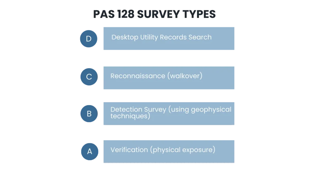
PAS 128 defines four survey types, each offering a different level of certainty depending on project stage and risk.
Type D is the starting point and is based purely on existing utility records. These records are sent by utility providers who may affected services within the scope of the utility survey. It’s useful early on, but it comes with obvious limitations because records can be incomplete, old, or schematic rather than accurate.
Type C builds on this by adding site reconnaissance. A site walkover identifies visible features such as manhole and inspection chamber covers, valves, cabinets, trench scars and utility markers, helping to sense-check what the records suggest is present.
Type B is where the real detection work begins. This survey type combines records, reconnaissance, and geophysical detection, typically using electromagnetic locating (EML) and ground penetrating radar (GPR) to locate and trace services across the site. Type B surveys is where horizontal and vertical location accuracy is introduced to provide more detail about each service within the survey scope.
Finally, there’s Type A, this is the highest level of certainty and involves verification through visual inspection of the service. This can be from an access point such as a manhole or inspection chamber or by excavation such as trial holes or vacuum excavation. This can be used when exact position and depth are critical to design plans or where other survey results were ambiguous.
Quality Levels (QL-A to QL-D
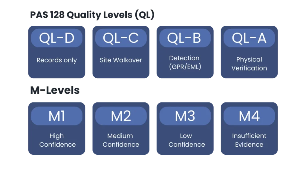
Alongside the survey type, PAS 128 assigns a Quality Level (QL) to the utility information. This is the quick way to understand how the information was obtained and how accurate it is.
- QL-D is based on records alone
- QL-C adds visual site evidence (Street furniture, topographical features, trench scar)
- QL-B reflects detection using geophysical methods such as GPR/EML
- QL-A is confirmed by physical exposure
This matters because two lines on the same drawing might look identical, but their quality level can tell you they are worlds apart in reliability.
What is a B Level?
Within a Type B survey, PAS 128 uses B-levels to describe the confidence in each individual utility feature and the basis on which it has been mapped.
- B4 is the lowest confidence detection outcome, typically used on services which are expected to exist (either on QL-D or QL-C records) but could not be detected and is therefore shown as an assumed route as no accurate horizontal or vertical position could be confirmed.
- B3 is used when a utility has been detected by one geophysical technique but there is no reliable depth measurement. This means the utility cannot be consistently traced and is defined using partial detections, interpretation, and supporting evidence rather than a continuous signal.
- B2 indicates good confidence in both horizontal and vertical accuracy but has only been verified by either EML or GPR. This is used for a utility which has been traced with a continuous response, and the depths are consistent across the trace.
- B1 represents the highest confidence detection outcome for a utility, typically where the utility has been clearly and continuously traced and its position and depth are strongly supported by both EML and GPR.
The practical value here is that B-levels stop people treating all “detected” utilities as equal. They highlight where the survey is robust and confidence in findings is high and where risk still exists.
If the quality level is followed by a “P” suffix, B2P for example, this indicates that the GPR data has been collected and post processed, which can improve interpretation, help clarify responses, and increase confidence in what is being mapped, especially on complex or busy sites.
PAS128 Utility Survey Methodology
PAS 128 also defines M-levels to describe how the survey was carried out in terms of methodology and coverage, particularly the spacing of the data capture across the site.
M4P represents the tightest survey spacing and the most intensive coverage, increasing the likelihood of detecting smaller, shallower, or more complex utilities. Used where the density of utilities is typical of a congested city area. M3P is a slightly wider spacing and is commonly used where the density of services is typical of a busy urban area or for clearance surveys prior to operations such as borehole/drilling. M2 and M1 involve progressively wider spacing and are typically more appropriate for lower-risk areas or in undeveloped areas.
Why PAS 128 Matters
Instructing a PAS 128 Utility Survey is not a tick box exercise. It is about reducing risk where it matters most. By clearly setting out what’s been surveyed, what’s been detected, and how confident the results are, it helps make informed decisions before work starts. The result is fewer surprises on site, fewer clashes, fewer delays, and a significantly reduced risk of expensive utility strikes
At Adaptive Surveys, we follow to PAS 128 specification because it gives our clients confidence. They know exactly what we’ve done, how we’ve done it, and how reliable the results are right down to each individual utility line.
If you require a PAS 128 Utility Survey, Adaptive Surveys provides high-accuracy, fully geo-referenced utility mapping tailored to your project’s needs.
Get in touch today to see how we can help.


