Following on from our previous blog about PAS 128, we’re going to talk about how to choose the right PAS 128 survey type.
Let’s take a brief recap.
The Four PAS 128 Survey Types (A–D)
PAS 128 defines four survey types, each offering a different level of certainty depending on project stage and risk.
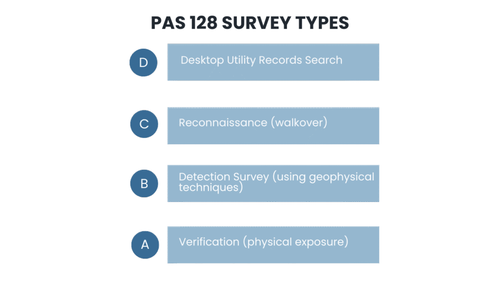
Type D is the starting point and is based purely on existing utility records. These records are sent by utility providers who may have affected services within the scope of the utility survey. It’s useful early on, but it comes with obvious limitations because records can be incomplete, old, or schematic rather than accurate.
Type C builds on this by adding site reconnaissance. A site walkover identifies visible features such as manhole and inspection chamber covers, valves, cabinets, trench scars and utility markers, helping to sense-check what the records suggest is present.
Type B is where the real detection work begins. This survey type combines records, reconnaissance, and geophysical detection, typically using electromagnetic locating (EML) and ground penetrating radar (GPR) to locate and trace services across the site. Type B surveys are where horizontal and vertical location accuracy is introduced to provide more detail and certainty about each service and its physical location within the survey scope.
Finally, there’s Type A, this is the highest level of certainty and involves verification through visual inspection of the service. This can be from an access point such as a manhole or inspection chamber or by excavation such as trial holes or vacuum excavation. This can be used when exact position and depth are critical to design plans or where other survey results were ambiguous.
If you’ve ever tried to commission an underground utilities survey, you’ll know the first big question is: “What type of PAS 128 survey do I actually need?”
It’s a fair question. The specification offers lots of options – Types A to D, different B-levels, different M-levels – and for many clients it can feel unnecessarily complicated. But choosing the right level of survey doesn’t need to be confusing. In fact, it mostly boils down to two things:
- Where you are in the design or construction lifecycle?
- How accurate does your utility information need to be?
Why does project phase influence your decision?
Generally, when a project is just getting off the ground, you don’t need highly detailed survey information. At this point, you’re looking for broad constraints, not precise depths. That’s where Type D and Type C come in. A Type D (desktop search) gives you a quick look at what the records say. A Type C adds a site visit, which helps confirm what’s visible and what might be missing. These are great for early feasibility studies or when you’re still shaping the concept design.
Once you move into outline or detailed design, accuracy becomes much more important. Designers need to know exactly where utilities are so they can avoid conflicts and plan safely. This is where a Type B survey becomes essential. It gives you detection-based information and that’s what makes it so valuable.
When we’re reaching the final phase before construction starts, Type A is the smartest choice, especially where there are critical interfaces between the design and the existing services on site. This survey acts as your final check by physically exposing utilities so you know exact depths and positions before you break ground.
In other words, low accuracy early on and higher accuracy as the project progresses.
Project phase is important, but what about risk?
Some sites carry far more risk than others. A rural greenfield development is very different from excavating next to a hospital switch room or a city centre fibre backbone. If the consequences of hitting a utility are high, then your accuracy requirements and therefore your survey requirements need to match that risk.
Excavation depth matters too. Light landscaping doesn’t need the same level of precision as deep drainage trenches or foundations for multi-storey construction. Likewise, heavily congested areas may require tighter survey spacing simply to make sense of the maze of buried infrastructure.
And in many cases, the decision is out of your hands as insurers, designers and CDM regulations often dictate the minimum confidence levels required before excavation can go ahead.
Making sense of B-Levels and M-Levels
This is where clients understandably feel the most uncertainty. So, let’s break it down.
B-levels describe the density of the scanning and how closely the survey lines were spaced. B1 represents the highest confidence detection outcome for a utility, typically where the utility has been clearly and continuously traced and its position and depth are strongly supported by both EML and GPR detection techniques. B4 on the other hand, is the lowest confidence detection outcome, typically used on services which are expected to exist (either on QL-D or QL-C records) but could not be detected by the surveyor on site and is therefore shown as an assumed route as no accurate horizontal or vertical position could be confirmed.

M-levels describe how the survey was carried out in terms of methodology and coverage, particularly the spacing of the data capture across the site. M4P represents the tightest survey spacing and the most intensive coverage, increasing the likelihood of detecting smaller, shallower, or more complex utilities. Used where the density of utilities is typical of a congested city area. M3P is a slightly wider spacing and is commonly used where the density of services is typical of a busy urban area or for clearance surveys prior to operations such as borehole drilling. M2 and M1 involve progressively wider spacing and are typically more appropriate for lower-risk areas or in undeveloped areas. The P designation behind the M-levels signifies that the GPR data has been recorded during the survey field work and subsequently post-processed and interrogated by the surveyor in the office following the data capture. Post processing of GPR data in some cases can significantly improve the clarity, accuracy, and interpretability of subsurface information by reducing noise, clutter and background reflections providing cleaner and easier to interpret data.
Typically clients don’t need to become experts in these classifications; they just need to understand that they directly affect how reliable the information is.
How Adaptive Surveys Helps You Decide
When a client comes to us unsure about which PAS 128 level they need, we start by asking a few simple questions:
- What stage is your project at?
- How deep will you be excavating?
- How congested is the area?
- What utilities are likely to be present?
- Are there any designer or insurer requirements?
Once we’ve discussed the project in more detail it becomes clear which survey type and accuracy level is appropriate. Our goal is always the same – provide the level of certainty you need without overspecifying and risking project budgets.
Sometimes that means a simple desktop search. Sometimes it means full B1 coverage with selective Type A verification. Whatever the scenario, we make sure the specification matches the risk.
If you require a PAS 128 survey, Adaptive Surveys provides high-accuracy, fully geo-referenced utility mapping tailored to your project’s needs.
Find out more about our Utility Services: Utility Surveys at Adaptive Surveys


